
Introduction
The map of Europe in 815 CE looked very different from today’s modern map. This was a time of powerful kingdoms, large empires, and major changes that shaped the future of the continent. Understanding what Europe looked like in 815 CE helps us see how history unfolded and how borders changed over time.
In this article, we’ll explore the key political powers, important events, and why the 815 CE map of Europe is important even today.
History of Europe Around 815 CE
In 815 CE, Europe was in the early Middle Ages, often called the Dark Ages. This was a period after the fall of the Western Roman Empire. It was a time of rebuilding, warfare, and the rise of new powers.
One of the most important leaders of this time was Charlemagne. He ruled over a huge empire called the Frankish Empire. In 800 CE, Charlemagne was crowned Emperor of the Romans by the Pope. This moment symbolized a strong connection between the Church and European kings.
However, Charlemagne died in 814 CE. By 815 CE, his son, Louis the Pious, became the emperor. Europe was strong under their rule but would soon face divisions.
Political Map of Europe in 815 CE
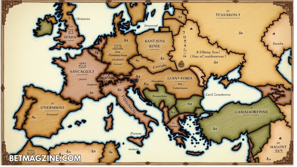
The political map of Europe in 815 CE was dominated by large empires and small kingdoms. Unlike today’s many countries, Europe was divided into a few large areas controlled by powerful rulers.
Some major parts included:
- The Carolingian Empire (Frankish Empire) in Western Europe
- The Byzantine Empire in Eastern Europe
- Various Slavic tribes in Eastern and Central Europe
- The Kingdom of Asturias in Spain
- The Papal States in Italy
- The Avars and Bulgars in parts of Eastern Europe
There were no Germany, France, or Italy as we know them today. Instead, these areas were all parts of bigger kingdoms or tribes.
Key Kingdoms and Empires in 815 CE
1. The Carolingian Empire
- The Carolingian Empire was the most powerful force in Europe in 815 CE.
- It covered modern-day France, Germany, the Netherlands, Belgium, Switzerland, Austria, and parts of Italy and Spain.
- Louis the Pious was trying to hold the empire together after his father Charlemagne’s death.
2. The Byzantine Empire
- In the east, the Byzantine Empire was the continuation of the Roman Empire.
- Its capital was Constantinople (modern-day Istanbul).
- It controlled Greece, the Balkans, parts of Italy, and areas of the Middle East.
3. Viking Lands
- The Scandinavian region (modern Norway, Sweden, Denmark) was home to Vikings.
- Though not unified, Vikings were becoming powerful and started raiding parts of Europe.
4. Slavic Tribes
- In Eastern Europe, many Slavic tribes were rising.
- They were not yet organized into big nations like Poland or Russia.
5. The Papal States

- The Papal States were territories in Italy directly controlled by the Pope.
- They played a huge religious and political role during this time.
6. Islamic Spain
- Parts of Spain were under the rule of Muslim Caliphates.
- The Emirate of Córdoba was the main Islamic state in the Iberian Peninsula.
Changes After 815 CE
The map did not stay the same for long. After 815 CE:
- The Carolingian Empire began to split due to internal conflicts.
- In 843 CE, the Treaty of Verdun divided the empire into three parts, which later influenced the creation of Germany and France.
- The Viking Age began. Vikings raided and later settled in parts of Britain, France, and Ireland.
- New kingdoms like England, Scotland, and Hungary started forming.
These changes reshaped Europe forever.
Importance of the 815 CE Map Today
Understanding the map of Europe in 815 CE is important because:
- It shows the roots of modern countries like France, Germany, and Italy.
- It explains early religious and cultural divisions between Eastern and Western Europe.
- It highlights how powerful leaders like Charlemagne influenced European history.
The 815 CE map is often used by historians to explain the transition from ancient times to the medieval world.
Conclusion

The map of Europe in 815 CE reveals a continent of large empires, tribal lands, and powerful leaders. Although borders were fluid and wars were frequent, this period laid the groundwork for the Europe we know today.
From Charlemagne’s massive empire to the Byzantine control in the East, each part of Europe had a story that shaped its future. When we look back at the 815 CE map of Europe, we see not just old kingdoms but the early footsteps of modern nations.
FAQs
What was the biggest empire in Europe in 815 CE?
The Carolingian Empire was the largest and most powerful empire in Europe at that time.
Who ruled Europe in 815 CE?
Louis the Pious, son of Charlemagne, ruled the Carolingian Empire in 815 CE.
Was there a Germany or France in 815 CE?
No, modern Germany and France did not exist. They were part of the Carolingian Empire.
What happened after 815 CE in Europe?
Europe saw the split of the Carolingian Empire, Viking invasions, and the rise of new kingdoms like England and Hungary.
Why is the 815 CE map important?
It helps us understand the early medieval period and the formation of modern European countries.


